> For the complete documentation index, see [llms.txt](https://knowledge.flyability.com/llms.txt). Markdown versions of documentation pages are available by appending `.md` to page URLs; this page is available as [Markdown](https://knowledge.flyability.com/third-party-software/faro-connect.md).
# FARO Connect
SLAM processing software for LiDAR data collected with the Elios 3. Formerly GeoSLAM Connect.
FARO Connect is a powerful software solution to process and manage the Elios 3’s LiDAR data. Powered by a leading SLAM algorithm, FARO Connect converts data from the Elios 3 into highly accurate point clouds and provides a range of SLAM presets, optimized for the most common data capture scenarios of the Elios 3.
## General Information
The following links can provide basic information to start using FARO connect:
{% content-ref url="/pages/ZPOKg9Iawqpq52uxCAUJ" %}
[System Requirements](/third-party-software/faro-connect/general-information/system-requirements.md)
{% endcontent-ref %}
{% content-ref url="/pages/AeoVQPb3Ea6w8iX4o20g" %}
[Software Download - Current FARO Connect and Flyability script installer](/third-party-software/faro-connect/general-information/software-download-current-faro-connect-and-flyability-script-installer.md)
{% endcontent-ref %}
{% content-ref url="/pages/3nP6BD4mtgyagu5pObes" %}
[File formats used by FARO connect](/third-party-software/faro-connect/general-information/file-formats-used-by-faro-connect.md)
{% endcontent-ref %}
{% content-ref url="/pages/nbfRBnhhqzp3Fh1IJYbY" %}
[GeoSLAM Connect (end of life)](/third-party-software/faro-connect/general-information/geoslam-connect-end-of-life.md)
{% endcontent-ref %}
{% content-ref url="/pages/vmfVPf85X9XmBbFF5aSa" %}
[Available Training](/third-party-software/faro-connect/general-information/available-training.md)
{% endcontent-ref %}
## How to.. step by step
{% content-ref url="/pages/RzHYayEYgaZcA4RbNhZJ" %}
[How to Install FARO connect](/third-party-software/faro-connect/how-to..-step-by-step-guides/how-to-install-faro-connect.md)
{% endcontent-ref %}
{% content-ref url="/pages/Ypj4mJLWMBOBY22KuR2j" %}
[How to process a point cloud](/third-party-software/faro-connect/how-to..-step-by-step-guides/how-to-process-a-point-cloud.md)
{% endcontent-ref %}
## FARO / FAQ Troubleshooting
{% content-ref url="/pages/0ifft0LWAu6UogVhK6AV" %}
[FARO FAQ / Troubleshooting](/third-party-software/faro-connect/faro-faq-troubleshooting.md)
{% endcontent-ref %}
## Latest News:
Have questions about, or need help with FARO connect? Go to our new [FARO FAQ / Troubleshooting](/third-party-software/faro-connect/faro-faq-troubleshooting.md) article covering the most common questions, and help guide you when encountering friction.
***
Starting with the Elios 3 update 2025.01, we have replaced the .bag file with an .mcap file. To process the flight in FARO connect a .geoslam file can be exported using Inspector 5.
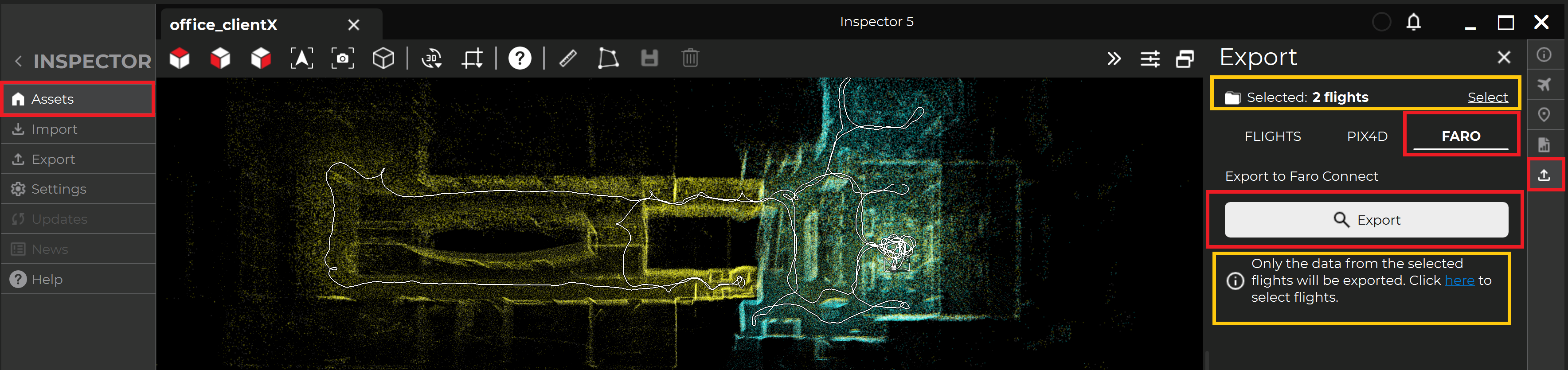
**How to export the geoslam file/s to process in FARO connect.**
Inspector 5 Export tab. Export one or multiple flights.
Navigate to the project in Inspector 5. Select the Export tab in the right side bar. Select FARO, and with the appropriate flight/s selected Click Export.
For more information: [Release notes](https://drive.google.com/file/d/1l7_StkIQZ78CjgRgI76cv-F8n8cnBvDC/view?usp=drive_link)
***
A new Flyability script version 1.8 has been released and is needed for the FARO connect version 2025.1 to work without error. Please remember to update the Flyability script when updating FARO connect.
For more information: [Download - Current FARO Connect and Flyability script installer](/third-party-software/faro-connect/general-information/software-download-current-faro-connect-and-flyability-script-installer.md)
---
# Agent Instructions
This documentation is published with GitBook. GitBook is the documentation platform designed so that both humans and AI agents can read, navigate, and reason over technical content effectively. Learn more at gitbook.com.
## Querying This Documentation
If you need additional information that is not directly available in this page, you can query the documentation by asking a question.
Perform an HTTP GET request on the following URL with the `ask` and `goal` query parameters:
```
GET https://knowledge.flyability.com/third-party-software/faro-connect.md?ask=&goal=
```
`ask` is the immediate question: it should be specific, self-contained, and written in natural language.
`goal` is what the user is ultimately trying to achieve, the reason they need the answer. Sharing it helps GitBook give you a better, more relevant answer. A goal is most helpful when it describes the outcome the user wants rather than restating the question. For example, with `ask=how do I create an API token`, a goal like `automate deployments from our CI pipeline` lets GitBook tailor the answer to that use case.
The response will contain a direct answer to the question and relevant excerpts and sources from the documentation.
Use this mechanism when the answer is not explicitly present in the current page, you need clarification or additional context, or you want to retrieve related documentation sections.