> For the complete documentation index, see [llms.txt](https://knowledge.flyability.com/llms.txt). Markdown versions of documentation pages are available by appending `.md` to page URLs; this page is available as [Markdown](https://knowledge.flyability.com/software/inspector-online/inspector-online-release-notes.md).
# Inspector Online Release Notes
Here, you’ll find a summary of all our Inspector Online releases, highlighting what’s new with each update.
## October 2026
#### New features
### High accuracy mapping
We're introducing High Accuracy Mapping: survey-grade point cloud processing for Elios 3 data, directly in Inspector Online and powered by FARO Insight.
The map the Elios 3 builds during the flight is robust and available right away. But because it's computed in real time, drift can build up over long or repetitive trajectories. High Accuracy Mapping runs a second SLAM pass after the flight. It optimizes the full trajectory to reduce that drift and produces a denser, more accurate point cloud. Until now this meant running FARO Connect on a dedicated workstation. Now you start it with one click in your browser and it processes in the cloud. The result appears in the same viewer as the rest of your inspection, with no processing PC and no extra software.
What you can do
* Process in one click. Open the inspection, select Process on a flight, and choose the environment preset (Standard, Tunnel or Outdoor), noise filter and SLAM strength. The LiDAR revision is detected automatically.
* Keep working while it runs. Processing happens in the background, and you can follow progress in the background tasks panel.
* Compare with the live map. The optimized point cloud and trajectory are shown alongside the original map and the rest of your inspection data.
* Export or sync back. Download the optimized map as .las, or sync it back to Inspector Desktop to continue your workflow there.
* Share everything in one link. Optimized point clouds are shared with the rest of the inspection, and recipients don't need to install anything.
Good to know
* Requires an active Premium Software Subscription and the 3D Survey Add-on.
* Georeferencing isn't available in Inspector Online yet. FARO Connect is still available for offline processing and advanced workflows such as automatic GCP target detection.
* Inspector Desktop 2026.03 or higher is required to sync the optimized map back.
* Snapshots are displayed on the original trajectory, and optimized maps can't be colorized yet.
Learn more about [High Accuracy Mapping](https://knowledge.flyability.com/ham)
#### Autoscan basic support
AutoScan captures now show up in Inspector Online, so you can browse the scan grid in the 3D viewer as you do in Inspector Desktop. The improved photogrammetry export is still only in Inspector Desktop.
Learn more about [Autoscan](https://knowledge.flyability.com/autoscan)
#### Improvements
* Performance of the inspection viewer improved with lots of snapshots or POIs
#### Bug fixes
* Solved an issue where customers can’t delete specific assets after moving them.
***
## July 2026
### **User friendly export**
**We're excited to introduce User Friendly Export**, the easiest way to get your inspection data out of Inspector Online, whether that's a single video, one point cloud, or a full inspection.
Until now, getting your data back out usually meant opening Inspector Desktop. Now you pick exactly what you need straight from your browser and download it as a single zip. No Inspector Desktop, no USB drives, no large file transfers.
#### **What you can do**
* **Export from the web in a few clicks**. Open any inspection, go to the Export tab, choose what you need, and start the export.
* **Select exactly what you want**. Pick individual flights, and choose the file types: annotated and raw snapshots (.jpg), video and thermal video (.mp4), maps, colorized maps and inspection map (.las), trajectory (.csv), mesh (.glb), and UT data (.csv).
* **Bundle flights together or keep them separate**, depending on how you want to hand the data over.
* **See the estimated size** before you start, so there are no surprises.
#### **Data you can actually use**
* **Human-readable folders and file names.** Exports use the same clear naming as Inspector Desktop (organized by asset and flight name), never internal IDs, so you can find what you need without opening the app.
* **Always notified by email.** When your export is ready, we email you a download link. If you stay on the inspection page, the download also starts automatically.
* **Download link valid for 30 days**, so you have time to retrieve and archive your data.
* **Available to your whole team**. Any role in your organization can export data, with access governed by your existing permissions.
Learn more about exporting your data
### Improvements
* Video and 3D viewer can be resized or maximized in inspection viewer
* Possibility to change Unit System and Temperature Unit
* Improved possibility to search sort and revoke all shared links
***
## May 2026
### Simplified sharing
We're excited to introduce Simplified Sharing, the easiest way to share an Inspector Online inspection with people outside your organization.
Generate a secure read-only link, send it over, and your recipient opens the inspection directly in their browser, no Flyability account, no software install, no friction.
Built for the moments when delivery has to be fast and simple: service providers handing results to a client, asset owners sharing findings with an external auditor, or teams looping in a contractor for a one-time review.
Simplified Sharing replaces invitations, account setup, and large file transfers with a single, controllable link.
\
**What you can do**
* **Create a secure link in seconds**. Open any inspection, click Share link, set your options, and copy the URL.
* **Send it to anyone**. Recipients open the link in their browser and explore the full inspection (flights, points of interest, measurements, maps) without logging in or installing anything.
* **Manage your links**. Add a label to recognize each link at a glance later. They can be revoked anytime.
#### **Stay in control of every shared inspection**
The feature is designed to give you confidence about what you share, with whom, and for how long.
* **Choose when the link expires**: 1 day, 1 week, 1 month, 3 months (default), or up to 1 year.
* **Limit the number of views**: keep the default of 100 views, or open it up for unlimited access if you'd rather not cap it.
* **Revoke any link instantly**: access ends within seconds of revocation.
* **See how your links are used**: track total access count, last accessed date, and link status from the Share link dialog.
* **Read-only by design**: recipients can view and download, but they cannot edit, delete, or modify anything in your inspection.
* **Org-wide control for administrators**: your organization administrator can enable or disable Simplified Sharing for the whole organization in Settings.
#### **A quick word on safe sharing**
A shared link works for anyone who has it. Treat it like a password: send it only to people you trust, and revoke it if it ends up somewhere it shouldn't. For sensitive inspections, use shorter expirations and a tighter view limit.\
[Learn more about the security of the feature](https://knowledge.flyability.com/inspector-online-simplified-sharing-security)
#### Improvements
* Improved user message when the Inspection is empty
***
## April 2026
#### New feature
* UT single crystal support
* Ability to filter pointclouds according to intensity values
#### Improvements
* Display snapshot and POI count on inspection card
* Ability to maximize the video player
* X,Y,Z coordinates are now shown in the 3D viewer (as on Inspector Desktop)
#### Bug fixes
* Increased the RSS Feed popup size so all text is visible
* Changed messages when uploading dataset to Inspector Online when jobs are still running
* Fixed issue that could cause video conversion timeout for very long flights (e.g. tether)
* Added minimum measurement labels size so they are always visible and readable
* Fixed misalignment in Thermal colormaps between Inspector Desktop and Inspector Online
## 2026-03-10 - Release 26.05.3
#### New feature
Added link to go to Inspection page from Comparison over time view and other way around
#### Improvements
Improved UX and sorting options for POIs in Comparison over time view
#### Bug fixes
* Fixed issue that would show never-ending video conversion in case of video missing
* General bug fixes and improvements
***
## 2026-02-24 - Release 26.04.0
#### Comparison over time
Comparison Over Time works hand in hand with Autonomous Repeat Flight, allowing you to analyze Points of Interest from repeat inspections side by side and make asset evolution immediately visible.
***
## 2025-12-02 - Release 25.25
### Colorization of Elios 3 Datasets
We’re excited to introduce **Colorization**, a new Inspector Online feature that adds intuitive visual context to Elios 3 inspections. With a single click, you can now generate **textured meshes** and **colorized point clouds** directly from your flight video and LiDAR data—no photogrammetry workflows required. These enriched 3D models make indoor assets easier to interpret, measure, and share.
Colorization enhances inspection clarity by revealing markings, stains, and structural features that may be invisible to LiDAR alone. It also supports safer operations by reducing the need for personnel to physically enter confined spaces, and it enables seamless remote collaboration thanks to anywhere-anytime access through Inspector Online.
#### Key benefits and capabilities include:
* **Faster interpretation** of complex indoor environments
* **Improved measurements** thanks to clearer visual references
* **Better communication** with non-technical stakeholders
* **Textured mesh generation** – Produce high-quality textured 3D meshes based on Elios 3 LiDAR and video data.
* **Colorized point clouds** – View point clouds enriched with real-world colors for clearer interpretation.
* **One-click processing** – Start colorization from the flight list in any inspection.
* **Easy sharing** – Share colorized datasets through a simple Inspector Online link; recipients can view results without installing software.
* **Downloadable outputs** – Export the textured mesh (.glb) or the colorized point cloud (.las) for offline use in Inspector.
The feature is available today for all Inspector Online **subscribers**, with **10 free credits** provided to new users who want to try it out. Processed outputs can be downloaded as textured meshes (.glb) or colorized point clouds (.las) for offline use in Inspector.
***
## 2025-08-06 - Release 25.15
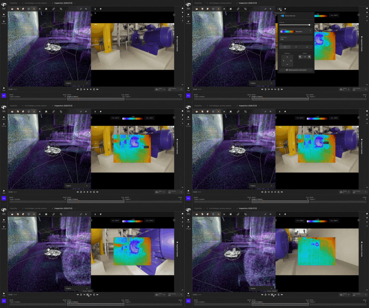
### Thermal Camera Visualization
You can now view and analyze thermal camera data directly in Inspector Online.
**Thermal overlay on RGB feed** – Visualize thermal imagery on top of the RGB camera feed for clearer context during inspections.
**Interactive parameters** – Fine-tune your thermal view with the following options:
* Opacity of the thermal overlay
* Colormap selection
* Emissivity adjustment
* Temperature unit (°C / °F)
* Overlay position and zoom
**Point temperature measurement** – Hover your mouse over the thermal image to display the temperature at that point.
**Consistency across platforms** – The thermal analysis experience now mirrors what you are familiar with in Flyability Inspector, ensuring a smooth transition between desktop and Inspector Online workflows.
This update makes it easier to review, share, and collaborate on thermal inspection data directly from your browser.
***
## 2025-06-25 - Release 25.13
#### Bug fixes
* Fixed upload issue that could cause the upload not to work
* Fixed issue preventing some assets to be deleted
***
## 2025-05-27 - Release 25.10
### Point Cloud Cropping in the 3D Viewer
You can now crop point clouds directly in the 3D viewer using a new tool that lets you isolate specific areas along the X, Y, and Z axes. This helps you focus on what matters most and simplifies the view of complex models.
### Performance Improvements
You’ll notice faster data loading and rendering thanks to general performance enhancements—making your experience smoother and more efficient across the platform.
***
## 2025-05-01 - Release 25.09
### Automatic Inspection Map Generation in Inspector Online
Inspection Maps are now automatically generated **directly in** Inspector Online. When you open an inspection that doesn’t already include an Inspection Map, the system will automatically generate one for you—no manual steps required. This simplifies the upload process and ensures you always benefit from optimized 3D rendering performance.
### Manual Flight Alignment in Inspector Online
You can now **manually align point clouds** from different flights within an inspection directly in Inspector Online. This feature gives you greater control over your dataset organization and alignment accuracy.
#### Key functionality includes:
* Select and move individual flight point clouds within an inspection
* Automatically re-generate the Inspection Map to reflect any changes
### Other features in this release
* Improved performances of the 3D Viewer and Video Playback to avoid video freeze.
* Bug fix on the data upload.
***
## 2025-04-24 - Release 25.08
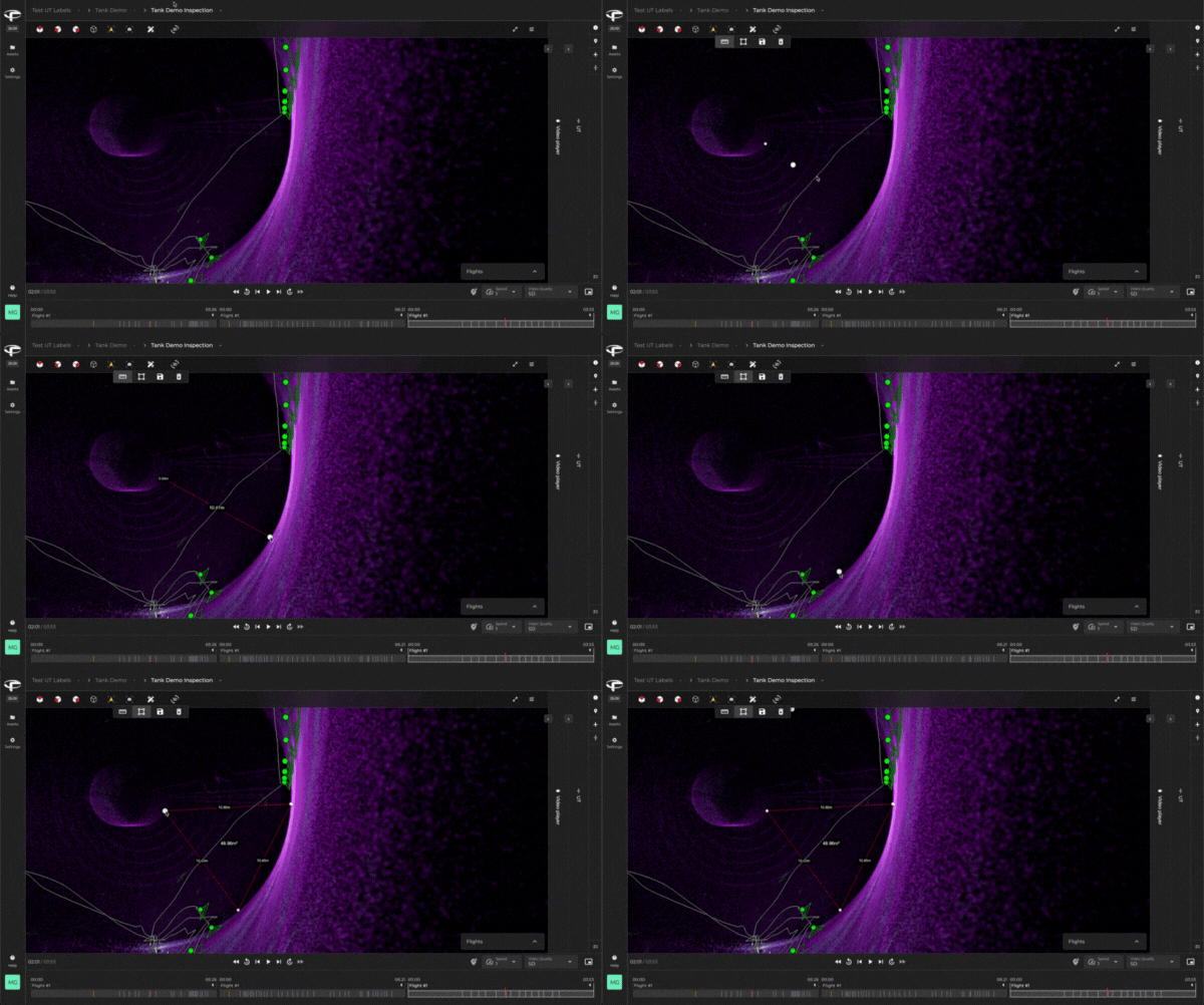
### Measurement Tool in the 3D Viewer
We’re pleased to announce the release of the Measurement Tool, now available in the 3D viewer in Inspector Online.
This new feature allows users to make **distance and area measurements** directly on the **3D model of their asset**. Whether you’re verifying dimensions, assessing surface areas, or validating structural details, the **Measurement Tool** provides an intuitive way to extract valuable spatial information right from within the Inspector Online interface.
### Other features in this release
* UT label are now displayed directly in the 3D Viewer
* Various bug fixes
***
## 2025-03-25 - Release 25.06
### UT Data Visualization
We’re excited to introduce support for **visualizing UT data** captured with Elios 3 directly within the Inspector Online platform. This enhancement enables a more comprehensive view of inspection results, providing deeper insights and improving collaboration.
With this release, UT data can be:
* Uploaded as part of your inspection datasets
* Viewed alongside other inspection elements in the Inspector Online interface
#### Known Limitation:
UT data will only be available for **datasets uploaded after this release**. If your data was uploaded prior to this update, you’ll need to **reupload the dataset** to enable UT data visualization.
### Other features in this release
* Various bug fixes
***
## **2025-02-11 - Release 25.05**
### **Editing Capabilities in** Inspector Online
Collaboration just got easier! You can now edit data and create snapshots directly in Inspector Online, making it simple to work with colleagues and clients in real time.
To enable Inspector Online editing, you can:
* Invite users to your organization with **Editor, Manager,** or **Administrator** permissions.
* Share an Asset with specific users as an **Editor** or **Manager**.
### **What You Can Edit in** Inspector Online**:**
**Asset:** Name, Description\
**Inspection:** Name, Description\
**Flight:** Name, Description\
**Snapshot:** Name, Criticality, Description
You can also:
* Create new snapshots
* Create, edit, and delete tags on snapshots
### **Inspection Map for Improved Rendering Performance**
We’re optimizing how point clouds are rendered in the browser! The new **Inspection Map** aggregates all flight point cloud data into a single Inspection point cloud, reducing resource usage and improving performance, especially for large datasets from the Elios 3.
This means the browser uses fewer computing resources, preventing performance issues and video playback from stopping when working with multiple flights.
#### **Known Limitation:**
To generate an Inspection Map, **open the inspection in Inspector before uploading it to Inspector Online.**
**Other features in this release**
✅ Introduction of a **background task panel** for tracking ongoing processes.\
✅ Various **bug fixes** improving 3D rendering and data upload/download.
***
## 2024-11-04 - Release 24.22
In this release, we added a new feature that lets users redeem payment codes, enabling them to purchase a license through traditional sales channels instead of exclusively through online credit card payments.
#### **New features**
* Payment code redemption
* Various bug fixes
***
## 2024-10-22 - Release 24.21
In this release, we made minor improvements to help you track your license usage by showing how many inspections you’ve used from your license allowance. We also added a new storage manager in Settings > Billing, allowing you to bulk delete assets and inspections to quickly manage your stored data and stay within your license limits.
#### **New features**
* License usage indicator
* Storage manager
* Various bug fixes
***
## 2024-09-24 - Initial release
We are excited to announce the very first release of Inspector Online, a powerful new tool designed to revolutionize how you manage, share, and collaborate on Elios 3 drone data. This initial release marks a significant milestone for Flyability, as we bring a solution that simplifies the entire process of drone data management, making it more efficient and accessible for teams and stakeholders.\
\
Inspector Online is an all-in-one platform that eliminates the need for USB drives, the headaches of large file transfers, and complex software installations. It allows you to easily upload, store, and access your Elios 3 data via WiFi or Ethernet, keeping everything centralized and synchronized across your devices and organization. The platform includes an online viewer optimized for Elios 3 data, letting users review inspection results, including maps, videos, and points of interest, directly from a web browser.\
\
Sharing data is just as simple, with one-click delivery to stakeholders, who can review everything without downloading extra software. Upcoming features will enhance collaboration by allowing teams to work on data together and integrate seamlessly with third-party applications. Security is a top priority, with data encryption, multi-factor authentication, and regular backups ensuring your information is protected.\
\
With Inspector Online, inspection data management has never been easier, and we are thrilled to introduce this groundbreaking tool to our community!
**Known Limitations**
* Datasets lacking LiDAR data (map and trajectory) may not display correctly, and video reviews are unavailable.
* UT, Thermal, and RAD data are not yet viewable in Inspector Online.
* Data editing is not currently supported in the Inspector Online environment.
* Downloading data from Inspector Online back to Inspector is not yet possible.
* Loading large datasets with numerous points of interest or multiple flights may take a few minutes, depending on your computer’s performance.
* Firefox is currently not supported.
---
# Agent Instructions
This documentation is published with GitBook. GitBook is the documentation platform designed so that both humans and AI agents can read, navigate, and reason over technical content effectively. Learn more at gitbook.com.
## Querying This Documentation
If you need additional information that is not directly available in this page, you can query the documentation by asking a question.
Perform an HTTP GET request on the following URL with the `ask` and `goal` query parameters:
```
GET https://knowledge.flyability.com/software/inspector-online/inspector-online-release-notes.md?ask=&goal=
```
`ask` is the immediate question: it should be specific, self-contained, and written in natural language.
`goal` is what the user is ultimately trying to achieve, the reason they need the answer. Sharing it helps GitBook give you a better, more relevant answer. A goal is most helpful when it describes the outcome the user wants rather than restating the question. For example, with `ask=how do I create an API token`, a goal like `automate deployments from our CI pipeline` lets GitBook tailor the answer to that use case.
The response will contain a direct answer to the question and relevant excerpts and sources from the documentation.
Use this mechanism when the answer is not explicitly present in the current page, you need clarification or additional context, or you want to retrieve related documentation sections.




.gif?alt=media&token=3b3e1982-9212-40ba-b3c1-4c6d3113cf28)
.gif?alt=media&token=13bc5f77-7f7f-4b12-9895-1b949e7c1cc7)